
In an era where precision is paramount, the role of surveying engineering has become increasingly significant. This discipline not only lays the groundwork for construction projects but also ensures long-term site accuracy, which is vital for the sustainability and safety of infrastructure. This article delves into the essence of surveying engineering, its methodologies, and its impact on long-term site accuracy.
Understanding Surveying Engineering
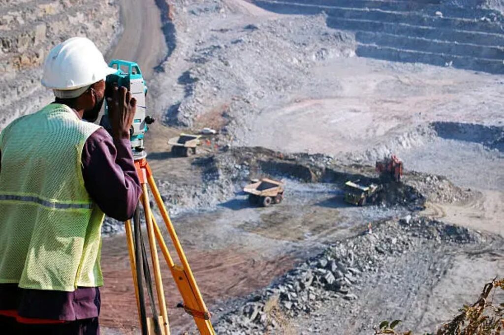
Surveying engineering is a branch of engineering that focuses on the measurement and mapping of the Earth’s surfaces. It encompasses a variety of techniques and technologies aimed at determining the relative positions of points, lines, and areas. Surveyors play a crucial role in the planning and execution of construction projects, ensuring that all elements are correctly positioned and aligned.
The Role of Surveyors
Surveyors are responsible for collecting data that informs the design and construction processes. They utilise advanced tools and technologies, such as GPS, total stations, and drones, to gather precise measurements. This data is essential for creating accurate site plans, which serve as the foundation for architectural and engineering designs.
Moreover, surveyors also conduct boundary surveys, which are critical for defining property lines and preventing disputes. Their expertise ensures that projects comply with local regulations and standards, thereby safeguarding the integrity of the construction process. In addition to these responsibilities, surveyors often collaborate with architects, engineers, and urban planners to provide insights that enhance project efficiency. Their ability to interpret complex data and translate it into actionable information is invaluable, particularly in large-scale developments where multiple stakeholders are involved.
Key Techniques in Surveying
Several techniques are employed in surveying engineering, each tailored to specific project requirements. Traditional methods, such as triangulation and trilateration, have been enhanced by modern technology. For instance, satellite-based positioning systems, like GPS, allow surveyors to achieve unprecedented accuracy over large distances.
Additionally, the advent of Geographic Information Systems (GIS) has revolutionised the way data is analysed and presented. GIS enables surveyors to create detailed maps and models that facilitate better decision-making throughout the project lifecycle. Furthermore, the integration of 3D laser scanning technology has provided surveyors with the ability to capture intricate details of complex environments. This technique not only speeds up the surveying process but also enhances the accuracy of the data collected, making it easier to visualise and analyse the spatial relationships within a site. As the field of surveying continues to evolve, the incorporation of artificial intelligence and machine learning is anticipated to further streamline operations, allowing for even more precise and efficient surveying practices in the future.
The Importance of Long-Term Site Accuracy
Long-term site accuracy is not merely a technical requirement; it is a fundamental aspect of successful project execution. Inaccuracies can lead to significant issues, including structural failures, costly redesigns, and legal disputes. Therefore, understanding the importance of maintaining site accuracy over time is crucial for all stakeholders involved.
Impact on Structural Integrity
One of the primary concerns in construction is the structural integrity of buildings and infrastructure. Any deviation from the original design can compromise the safety and durability of a structure. For example, if a foundation is not laid accurately, it can lead to uneven settling, resulting in cracks and other forms of damage.
Surveying engineering ensures that all elements of a project are built according to precise specifications. By conducting regular surveys throughout the construction process, engineers can identify and rectify any discrepancies before they escalate into major problems. This proactive approach not only safeguards the structure but also enhances the overall quality of the build, ensuring that it stands the test of time. Moreover, the integration of advanced technologies, such as 3D laser scanning and drone surveying, has revolutionised the accuracy of data collection, allowing for even more precise measurements and monitoring over the project’s lifespan.
Cost Implications
Inaccuracies in surveying can have significant financial repercussions. Rectifying errors often involves costly rework, delays, and additional resources. Furthermore, projects that are not completed on time can incur penalties and damage relationships with clients and stakeholders.
By investing in accurate surveying from the outset, companies can mitigate these risks. The initial costs associated with thorough surveying are often outweighed by the savings achieved through reduced errors and enhanced project efficiency. Additionally, the long-term benefits extend beyond immediate financial savings; they include improved reputation and client trust. A firm known for its commitment to precision and quality is more likely to attract repeat business and referrals, which can be invaluable in a competitive market. Furthermore, accurate site data can facilitate better project planning and resource allocation, ultimately leading to smoother operations and a more streamlined workflow.
Technological Advancements in Surveying
The field of surveying engineering has witnessed remarkable advancements in technology that have transformed traditional practices. These innovations have not only improved accuracy but also enhanced the speed and efficiency of surveying processes.
3D Laser Scanning
One of the most significant advancements in surveying technology is 3D laser scanning. This technique allows surveyors to capture detailed, three-dimensional representations of a site in a fraction of the time it would take using conventional methods. The resulting data can be used for a variety of applications, including design, analysis, and monitoring.
3D laser scanning is particularly beneficial for complex projects, where capturing intricate details is essential. It provides a comprehensive view of the site, enabling engineers to make informed decisions and adjustments throughout the project lifecycle.
Drone Surveying
Another groundbreaking technology is drone surveying. Drones equipped with high-resolution cameras and sensors can cover vast areas quickly, collecting data that would be time-consuming and labour-intensive to gather on foot. This method is especially useful in remote or difficult-to-access locations.
Drone surveying not only enhances data collection but also improves safety by reducing the need for surveyors to work in hazardous environments. The integration of drones into surveying practices has revolutionised the industry, making it more efficient and effective.
Ensuring Long-Term Site Accuracy
To achieve long-term site accuracy, it is essential to adopt best practices throughout the surveying process. This involves meticulous planning, continuous monitoring, and the use of advanced technologies.
Regular Monitoring and Maintenance
Long-term site accuracy requires ongoing monitoring and maintenance. Regular surveys should be conducted to assess any changes in the site conditions or structural integrity. This proactive approach allows for early detection of potential issues, enabling timely interventions.
Additionally, implementing a maintenance plan for existing structures can help preserve their accuracy over time. Regular inspections and updates ensure that any shifts or movements are addressed promptly, safeguarding the longevity of the infrastructure.
Collaboration and Communication
Effective communication and collaboration among all stakeholders are crucial for maintaining long-term site accuracy. Surveyors, engineers, architects, and construction teams must work together to ensure that everyone is aligned on project goals and specifications.
Utilising project management tools and platforms can facilitate better communication, allowing for real-time updates and information sharing. This collaborative approach helps to minimise misunderstandings and ensures that all parties are aware of any changes that may impact site accuracy.
The Future of Surveying Engineering
The future of surveying engineering looks promising, with ongoing advancements in technology and methodologies. As the industry continues to evolve, it is essential for professionals to stay abreast of new developments and adapt their practices accordingly.
Integration of Artificial Intelligence
Artificial intelligence (AI) is poised to play a significant role in the future of surveying engineering. AI algorithms can analyse vast amounts of data quickly, identifying patterns and trends that may not be immediately apparent to human surveyors. This capability can enhance decision-making processes and improve overall accuracy.
Moreover, AI can assist in automating routine tasks, allowing surveyors to focus on more complex aspects of their work. The integration of AI into surveying practices has the potential to revolutionise the industry, making it more efficient and effective.

Sustainability Considerations
As the world becomes increasingly focused on sustainability, surveying engineering must also adapt to these changing priorities. Incorporating environmentally friendly practices into surveying processes is essential for minimising the impact of construction on the environment.
Utilising technologies such as drone surveying and 3D laser scanning can reduce the need for extensive land disturbance, preserving natural habitats and ecosystems. Additionally, adopting sustainable materials and practices in construction can further enhance the long-term viability of projects.
Conclusion
Surveying engineering is a critical component of successful construction projects, ensuring long-term site accuracy and structural integrity. By embracing advanced technologies and best practices, professionals in this field can mitigate risks, reduce costs, and enhance the overall quality of their work.
As the industry continues to evolve, staying informed about new developments and embracing innovative solutions will be essential for maintaining high standards of accuracy. Ultimately, the commitment to precision and excellence in surveying engineering will pave the way for safer, more sustainable infrastructure for future generations.
Related : Benefits of Engineering Surveys for Roadworks and Transport Planning